Idaho Hunt Planner We got game.
Unit 63
- Region 6
- Upper Snake Region
- Snake River Elk Zone
- Units 53, 63, 63A, 68A
Game Management Unit Boundary
Those portions of BINGHAM, BONNEVILLE, BUTTE, CLARK, and JEFFERSON COUNTIES within the following boundary: beginning at Blackfoot then north on Interstate 15 to Dubois, then southwest on State Highway 22 to U.S. 20-26, then southeast on U.S. 26 to Interstate 15 at Blackfoot, the point of beginning. Camas National Wildlife Refuge - CLOSED.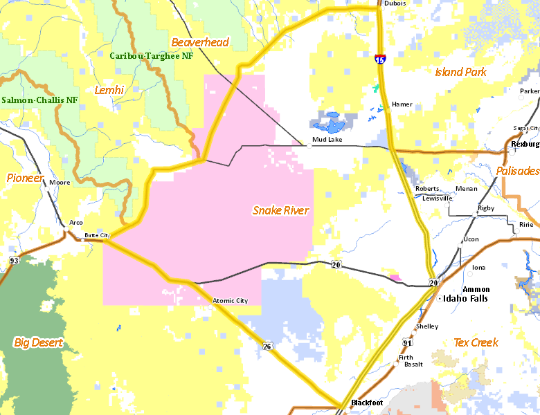
Public Access
Surface Management
For government land, these data show the managing agency of the land, which may or not be the same as the owning agency.
| U.S. Department of Energy (DOE) |  35.6
%
35.6
%
|
| Private |
35.58
%
|
| U.S. Bureau of Land Management (BLM) |
20.89
%
|
| State of Idaho |
6.83
%
|
| State of Idaho |
0.67
%
|
| Other |
0.19
%
|
| U.S. National Wildlife Refuge (NWR) |
0.16
%
|
| U.S. Military |
0.08
%
|
Make your own map of Unit 63
Ownership data source: Inside Idaho
Access Yes! Properties
No properties are currently available in Unit 63.
View all Access Yes Participants.
National Forests
No National Forest lands fall within Unit 63.
Federally-designated Wilderness Areas
No motorized vehicles are allowed in these areas.
There are no wilderness areas in Unit 63.
Land Use/Cover
| Rangeland |
60.03
%
|
| Irrigated-Sprinkler |
20.79
%
|
| Irrigated-Gravity Flow |
8.42
%
|
| Rock |
7.65
%
|
| Riparian |
1.74
%
|
| Dryland Agriculture |
1.23
%
|
| Urban |
0.14
%
|
Make your own map of Unit 63
Land Use data source: IDWR